The Question
Have you ever been on a long-haul flight and wondered: Exactly how far can this plane fly? Are we pushing its maximum limits, or is this a typical route? What if every single seat was full, or half the plane was empty?
I love thinking about this stuff. I’ll spot a 787 on the tarmac and immediately start calculating where it could go nonstop from my local airport. The problem is, the existing tools for visualizing this were boring, clunky, and mostly built for commercial pilots or aircraft buyers. They locked down the data, only featured aircraft I didn’t care about, and often felt highly inaccurate.
I just wanted a fast, visually appealing tool I could actually play with.
So, I built it.
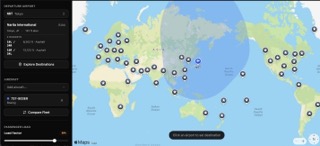
Introducing PlaneRange
PlaneRange is an interactive map where you pick a departure airport, choose an aircraft, and drag a passenger slider to watch the range ring shrink in real time. More passengers/load means more weight, which means less range, and you can see that tradeoff instantly on the map.
The core idea is dead simple: pick a plane, pick a city, and drag the slider.
Real Airline Configurations
A Delta A220-100 has 109 seats. A Swiss A220-100 has 125 seats. That difference matters, fewer seats means more range per passenger or more cargo. PlaneRange uses real airline seat configurations, not just manufacturer maximums, so you can see how your airline’s specific layout affects where the plane can actually go.
Every Category of Aircraft
Most range tools focus on general aviation or private jets. PlaneRange covers popular commercial airliners, private jets, and GA aircraft, 55 planes that a curious person would actually recognize. You’ve heard of the A380. You’ve seen a Cessna 172. Every aircraft in PlaneRange is one you’d recognize by name if you have been to an airport in the last couple years.
Click-First Map Experience
Click a pin to depart, click another to arrive. You can have up to five aircraft on the map at once, each with its own colored range ring, making it a visual playground for comparing planes side by side. And the best part it’s completely free, no signup required. For now!
A Game, Not a Flight Planner
PlaneRange is a game for curious people that happens to use real data. It’s not a flight planning tool. Real-world range depends on fuel load, altitude, temperature, winds aloft, and dozens of other variables that would make this way less fun if I tried to model all of them. The goal was to make something you could open on your phone, tap around for a few minutes, and walk away having learned something surprising, like the fact that a fully loaded 737 MAX 8 can quite make it from New York to London nonstop.
Try It Out
PlaneRange is live now and completely free. I’d love to hear what you think.
-Dan